

News
Council wins award for address data management


Pictured with the award: Adam Crocker, David Morgan, June Shobrook and Cllr Neil Prior.
PEMBROKESHIRE COUNTY COUNCIL’S management of its address information database has been recognised as the best in Wales.
The Authority was awarded Best in Region (Wales) at the recent national GeoPlace conference and presentation of the Exemplar Awards 2017.
The Exemplar Awards celebrate excellence in service delivery which has been enabled through local government address and street information.
Jason Houghton, Deputy National Address Data Manager, said: “Pembrokeshire County Council has achieved the highest standard of address information data management in Wales.
“Achieving this level demonstrates excellence and commitment to a process that brings local and national benefits.”

Local councils have a statutory requirement for street naming and numbering and are the source for the millions of address records of every residence and business in the UK.
“Addresses are invaluable to our economy and our public services,” added Jason. “They help make sure that emergency services get to our door as quickly as possible; confirm our identity; and help us to access products and services.”
The Award was given to Adam Crocker, LLPG (Local Land & Property Gazetteer) Administrator, David Morgan, GIS Information Co-ordinator and LLPG Custodian, and June Shobrook, Street Naming and Numbering Officer.
Cllr Neil Prior, Cabinet Member for Transformation and IT, said: “Managing and maintaining over 75,000 addresses is just one of the many unseen functions that Councils run that we couldn’t provide public services without.

“The fact that at Pembrokeshire we have one of the leanest IT teams in Wales makes this award even more richly deserved.”
The Best in Region Award is given to the authority which has attained the highest standard in national tests on data excellence, and supply of regular updates to the national hub which manages receipt of address data from all authorities in England and Wales.

DYFED-POWYS POLICE have launched a winter policing operation aimed at tackling town centre crime, antisocial behaviour and dangerous driving during the festive period.
The force is taking part in the Home Office’s Winter of Action campaign, with officers concentrating on crime “hotspots” across Dyfed, Powys and West Wales in the run-up to Christmas and New Year.
Police say the focus will be on reducing shoplifting, street crime and antisocial behaviour, alongside increased patrols linked to the night-time economy. The operation also includes measures targeting violence against women and girls, as well as alcohol-related disorder.
The winter campaign is being supported by Operation Ivydene, a dedicated antisocial behaviour initiative funded by the Office of the Police and Crime Commissioner. Dyfed-Powys Police received almost £500,000 in 2024 to deliver additional patrols and targeted responses in identified problem areas.
According to the force, Operation Ivydene delivered more than 12,000 hours of patrols during its first year, with reported antisocial behaviour falling by around 40% in hotspot locations.
The second year of the operation began this autumn. Inspector Darren Crockford said lessons learned during the first phase were now being used to broaden the focus.
He said: “Whilst we are still working towards the original aim of reducing antisocial behaviour, there is now an added emphasis on reducing serious violent crime, knife crime and retail crime.
“So far, over 2,050 hours of patrols have taken place across hotspot areas, with more than 70% of those patrols involving engagement with local businesses, charities and third-sector organisations.”
Operation Ivydene is currently active in a number of towns, including Haverfordwest, Milford Haven and Pembroke in Pembrokeshire, along with Ammanford, Llanelli and Carmarthen in Carmarthenshire, Aberystwyth and Lampeter in Ceredigion, and Newtown and Llandrindod Wells in Powys.

Community engagement forms a key part of the operation. Police say more than 6,300 surveys were carried out during the first year of Operation Ivydene to gather feedback from residents and businesses in hotspot areas.
Inspector Crockford added that the responses had helped officers better understand local concerns and shape patrol activity.
Alongside town centre policing, Roads Policing Units are also increasing patrols over the festive period, with a focus on drink and drug driving.

Police said officers would also be targeting the so-called “Fatal Five” offences – speeding, using a mobile phone while driving, not wearing a seatbelt, driving without due care, and driving under the influence of alcohol or drugs – which are the most common causes of fatal and serious collisions.
Dyfed-Powys Police covers more than 8,500 miles of road across the force area. Officers are urging drivers not to feel pressured into risky decisions and to take responsibility for staying safe behind the wheel.
Updates on the winter operation are being shared through Dyfed-Powys Police social media channels and the Dyfed-Powys Connects messaging service.

MEMBER of the Senedd Paul Davies MS has praised the “vital role” played by the voluntary sector in Pembrokeshire following a visit to PAVS – Pembrokeshire Association of Voluntary Services.
Mr Davies met with Chief Executive Jess Bickerton and members of the PAVS team, who provide support to individuals, volunteers, community groups and charities across the county.
During the visit, the Preseli Pembrokeshire MS was briefed on the wide range of advice, guidance and practical assistance offered by PAVS to help local organisations operate effectively and respond to community needs.
PAVS works closely with voluntary and third-sector groups, supporting everything from governance and funding applications to volunteering and community development, and plays a key role in strengthening local networks across Pembrokeshire.
Speaking after the visit, Mr Davies said the organisation’s work was crucial in helping communities thrive, particularly at a time when many voluntary groups are facing increasing pressures and rising demand for support.
He thanked Ms Bickerton and her colleagues for their work and for the warm welcome, describing their contribution as “invaluable” to communities throughout the county.
PAVS supports hundreds of organisations and volunteers each year and is a central hub for the voluntary and community sector in Pembrokeshire.

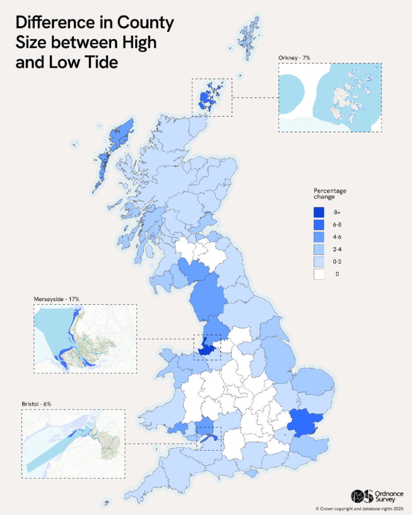
NEW data released by Ordnance Survey (OS) could significantly improve how coastal erosion and flood risk are monitored across Great Britain as sea levels rise and extreme rainfall becomes more frequent.
The continuous tidelines dataset provides a clearer and more accurate picture of where high and low tides fall around the coast and along tidal rivers. The data is expected to support environmental monitoring, flood modelling, and long-term planning as the impacts of climate change accelerate.
Earlier this year, the Environment Agency updated its National Flood Risk Assessment (NaFRA), which for the first time factored in projected climate change impacts. The assessment found that around 6.3 million homes and businesses in England — roughly one in five — are currently at risk of flooding. That figure could rise to one in four properties by 2050.
The Agency has also updated its national coastal erosion risk map, which estimates that around 3,500 properties could be affected by coastal erosion by 2055.
The new OS dataset builds on existing information held in the OS National Geographic Database (OS NGD). Previously separate tidal boundary features have now been automatically merged into continuous high- and low-tide lines, creating two new feature types within the OS NGD Water theme. These can also be used as overlay layers through the OS Tiles API, allowing for clearer visual mapping and large-scale analysis.
The data is expected to support a wide range of environmental and regulatory work, including coastal erosion and flooding modelling, updating boundary features to reflect coastal change, climate change impact assessments, and identifying areas of foreshore that act as natural flood defences.
William Russell, Senior Coastal Process Scientist at the Wales Coastal Monitoring Centre, said the dataset would remove uncertainty from coastal monitoring.
“One of our core values is ‘data, not opinions’. When information is missing, we seek out or collect the data needed to support sound decision-making,” he said.
“The OS Continuous Tidal Boundaries dataset removes uncertainty from our strategic monitoring programme and gives us clearer insight into intertidal extents, delivering cost savings and efficiencies for our survey contractors.”
Ordnance Survey says the data is particularly valuable for environmental policy and regulation, including decisions around water discharge and flood management. Accurately defining the intertidal zone helps identify natural coastal defences, which play a vital role in protecting communities and ecosystems.
Intertidal information has also been enhanced within the Land theme of the OS NGD, with improved coverage of previously obscured areas to create a more complete national coastal dataset.
Lily Brown, Product Manager at Ordnance Survey, said the data would support evidence-based decision-making.
“The OS National Geographic Database contains trusted, accurate features that support everything from climate resilience and infrastructure planning to coastal management,” she said.
“By incorporating authoritative tideline data, we are enabling decisions that will help protect and monitor Britain’s evolving coastlines.”
Following the dataset’s release, Ordnance Survey analysed how ceremonial counties change in size between high and low tide. Merseyside showed the greatest variation, with a nearly 17% difference, followed by Orkney at around 7%.
The analysis also highlighted that counties considered landlocked, such as Nottinghamshire and South Yorkshire, still experience significant tidal influence due to rivers like the Trent and the Don being tidal far inland.
When combined with Unique Property Reference Numbers (UPRNs), the tideline data shows that Greater London has the highest number of homes and businesses within 15 metres of the high-tide line, at around 5,500. Cornwall ranks second with just over 3,000 properties, followed by Devon with around 2,400.
The new data has been released under the Public Sector Geospatial Agreement (PSGA), which provides emergency services and public sector organisations with access to Ordnance Survey data and services.


Three inmates deny murder of Lola James killer at Wakefield prison
THREE prisoners have denied murdering child killer Kyle Bevan, who was found dead in his cell at HMP Wakefield. Bevan,...


Dyfed-Powys Police reassure communities after Bondi Beach mass shooting
Officers monitor local tensions following terror attack on Jewish event in Sydney DYFED-POWYS POLICE have issued reassurances to communities across...


Search under way in Pembroke Dock for missing man Lee
Coastguard, RNLI and rescue helicopter launched as fears grow he entered the water A MAJOR search and rescue operation is...


Search under way in Pembroke as man reported missing
Rescue teams battle worsening weather ahead of amber rain warning A MULTI-AGENCY search and rescue operation is under way in...

Amber weather warning as ‘danger to life’ rain set to hit Pembrokeshire
Dyfed-Powys Police and council teams prepare as Monday deluge expected COMMUNITIES across Pembrokeshire are being urged to brace for severe...


Former Army Cadet leader sentenced for child abuse image offences
Judge condemns “horribly abused” victims as Carmarthen man admits offences A FORMER Army Cadet instructor from Carmarthen has been sentenced...

Trefin dog case ends in forfeiture order after protection notice breach
Village protest followed months of complaints about barking A WOMAN from north Pembrokeshire has been fined £1,000 and ordered to...


Man spared jail after baseball bat incident in Milford Haven
Judge says offence was so serious only a prison sentence was justified A 44-YEAR-OLD has been given a suspended prison sentence after...


Rural cannabis factory exposed after five-year operation in Carmarthenshire
Family-run drugs enterprise brought in millions before police raid during lockdown A FAMILY who relocated from England to a remote...


Senedd rejects calls to ‘eliminate’ rates for small businesses
A CONSERVATIVE call to abolish rates for all small businesses in Wales has been voted down by the Senedd amid...
-

 Crime6 days ago
Phillips found guilty of raping baby in “worst case” judge has ever dealt with
-

 Crime5 days ago
Kilgetty scaffolder sentenced after driving with cocaine and in system
-

 Crime5 days ago
Housing site director sentenced after failing to provide breath sample following crash
-

 News1 day ago
Dyfed-Powys Police launch major investigation after triple fatal crash
-

 Crime5 days ago
Motorist banned for three years after driving with cannabis in system
-
Crime2 days ago
Man spared jail after baseball bat incident in Milford Haven
-

 Education4 days ago
Teaching assistant struck off after asking pupil for photos of her body
-

 Crime5 days ago
Milford Haven pensioner denies exposure charges