

News
Pembroke Dock: Councillors minded to refuse HGV tanker park plans

PROPOSALS to locate a HGV tanker park in Pembroke Dock have been described as ‘out of order’ by councillors.
The proposed location of the site is on land at Criterion Way, behind the Asda petrol station, but it has been met with objection from a number of councillors and locals.
Councillors also said that the proposed site was the wrong location, adding that there were a number of suitable alternatives.
After a lengthy debate at a meeting of the Planning Committee on Tuesday (Feb 8), councillors voted that they were minded to refuse the application.
Officers will now look at grounds for refusal before bringing it back to a future meeting of the committee.

Pembroke Dock Town Council had previously voiced their objections to the plans while at a previous meeting of the Planning committee, members voted to visit the site.
Cllr George Manning spoke again on behalf of the Town Council while Cllr Paul Dowson also expressed his concerns about the plans.
Asked about the types of lorries that could use the road, Cllr Dowson said that both types of the vehicles would ‘tear up the road surface’.
He also said that it would ‘hamper’ the efforts of those who currently work next to the proposed site.

Speaking passionately against the proposal, Cllr Brian Hall said: “I cannot understand the statement from the agent who says there are serious concerns if they cannot find a place. There are far more serious concerns for the people of the town.
“There has been no consideration for the people of Pembroke Dock. The Port Authority have had meetings with the Town Council and they have said they want to work with the town council and that they want to be good for the town. This is totally opposite, it is out of order, nobody really wants it here.
“I cannot believe that they haven’t looked sufficiently for other sites. This is total greed by the Port Authority, they don’t give a damn for the people of the town. I will move refusal of this, it is totally out of order.”

That was seconded by Cllr Tony Wilcox who said he agreed with what had already been said and added it was an ‘environmental hazard waiting to happen’.
“This is the wrong spot, they haven’t done their homework. The Kingswood site is absolutely ideal.”
Committee chair, Cllr Jacob Williams said it was his view that the proposed site was the wrong location and said he couldn’t see why there was a need to have empty tankers on that site.
Councillors heard from the agent who said there was no plan B and were told that it could lead to an appeal if they were to refuse it.
Cllr Hall said if it did there would be a petition signed by many people in Pembroke Dock and that this would cause ‘all sorts of problems’.
Other councillors said they were finding it difficult to decide but were minded to go with a refusal having heard what had been said.
Cllr David Pugh added: “We’ve got ourselves in a bit of a pickle with this one. I didn’t have a lot of concerns about the site itself but having listened to what has been said, on balance, I think this is the wrong location for this enterprise. I do support the ‘minded to refuse’ decision and hope that the agents might reconsider the alternatives. I have been struggling with this, it is a very difficult choice.”
Cllr Vic Dennis said it would basically be a big car park and that it wouldn’t bring much economic benefit to the town.
Before the vote was taken, Cllr Hall thanked members for their support.
Twelve members voted that they were minded to refuse the application, with one councillor abstaining.


SAMUEL Kurtz MS has welcomed more than £4.3 million in National Lottery funding awarded to community projects across Carmarthen West and South Pembrokeshire since 2021.
Figures released by The National Lottery Community Fund show that £4,318,484 has been distributed through 122 grants in the constituency since the 2021/22 financial year, the same year Mr Kurtz was elected.
The funding has supported a wide range of grassroots charities, voluntary organisations and community groups through programmes including National Lottery Awards for All, offering grants of up to £20,000, and People and Places, which provides larger awards of up to £500,000.
Projects backed locally include mental health support for young people, environmental and sustainability initiatives, community workshops, outdoor wellbeing activities, support for vulnerable adults, and programmes aimed at building skills and confidence.
Among the organisations to benefit is Pembrokeshire Coast National Park Authority, which received £343,584 for its Routes to Discovery project, helping improve mental and physical wellbeing through accessible outdoor activities.

St Davids Diocesan Council for Social Responsibility was awarded £398,078 to deliver its Plant Dewi: Strengthening our Communities initiative, supporting families and local groups.
Other recipients include The VC Gallery, Redberth Croft CIC, The Tenby Project CIC and Neptune’s Army of Rubbish Cleaners, with funding supporting projects ranging from food initiatives and nature-based wellbeing to volunteering and environmental action.
Mr Kurtz said: “Community groups and charities across Carmarthen West and South Pembrokeshire do incredible work supporting people and strengthening local communities.
“It is fantastic to see more than £4.3 million of National Lottery funding invested in projects that are improving wellbeing, tackling isolation and creating opportunities for people of all ages during my time in office.
“The voluntary sector plays a vital role in our area, and this funding is helping organisations deliver projects that bring people together and make a real difference to people’s lives.”
The National Lottery Community Fund is the largest funder of community activity in Wales, supporting initiatives that bring communities together, promote environmental sustainability, help children and young people thrive, and improve health and wellbeing.
Organisations across Wales can apply for funding through the Awards for All and People and Places programmes to support projects that matter most to their communities.
Further information is available on The National Lottery Community Fund website.

A NEW national framework aimed at securing a lasting legacy from the National Eisteddfod has been published jointly by the festival’s organisers and the Welsh Government.
The plan sets out how the Eisteddfod’s impact will be strengthened before, during and after each annual event, bringing together partners from across education, community development, culture, the economy and the Welsh language sector.
While each Eisteddfod reflects the identity of its host community, the framework aims to ensure long-term benefits are consistently delivered nationwide, rather than limited to the festival period.
The legacy programme will cover a wide range of areas including education, inclusion, digital innovation, volunteering and economic development, with new national and local structures designed to coordinate delivery more effectively.
A national project board will oversee the strategy, setting direction and sharing best practice year-on-year. At a local level, a steering group will drive community-based work, helping turn the Eisteddfod into a catalyst for lasting change.

Cabinet Secretary for Finance and the Welsh Language, Mark Drakeford said the festival’s impact goes far beyond a single week.
“The Eisteddfod is far more than a week-long festival. It is a multi-year project that leaves a lasting legacy for the Welsh language and culture in the area,” he said.
“By bringing together partners from across key sectors, this framework will help deliver real and lasting change for our communities and support our ambition of reaching a million Welsh speakers by 2050.”
Nic Parry, President of the Eisteddfod Court and Chair of its Management Board, said the framework strengthens collaboration at both local and national level.

“It allows us to deliver on a long-held ambition to drive language planning through the lens of the National Eisteddfod,” he said.
“It also positions the Eisteddfod as a powerful tool for boosting local economies and supporting sustainable communities for future generations.”
Further details are expected later this year, with membership of the national project board due to be confirmed by mid-June.

A dedicated session at this year’s Eisteddfod will also gather evidence from the 2026 host area to help shape future plans for 2027 and 2028.
More information is available via the Eisteddfod’s legacy framework online.
Tributes pour in for former Neyland officer remembered as a “true gentleman” and “local legend”
A FORMER Neyland police officer remembered as a “true gentleman” and “local legend” has died at the age of 83, prompting an outpouring of tributes from across Pembrokeshire.
Louis Knight, of Neyland Hill, Neyland, passed away peacefully at Withybush Hospital, Haverfordwest on Thursday (Mar 5).
Mr Knight, who served as a police officer in the area for many years, was a familiar and respected figure in Neyland and beyond. In the hours following the announcement of his death, hundreds of messages flooded social media, painting a picture of a man whose impact stretched far beyond his time in uniform.
Many described him simply as “one of the best,” while others called him “a proper local legend” and “a tremendous police officer.”
One resident wrote: “A face and name I will never forget from my youth.”
Another said: “He was a tremendous police officer… a kick up the backside and a word was enough. It stayed with you.”
Others remembered his warmth and humour away from policing.
“He always had a story to tell on the way home in the taxi,” one tribute read, while another added: “Every time you asked him how he was, the answer was always ‘bloody marvellous.’”
Many spoke of his kindness and the time he gave to people.
“Louis was one of the most kindest gentlemen around. Always made time to chat,” one message said.
Another added: “Neyland won’t be the same again.”
While some reflected fondly on a different era of policing, what came through most strongly was the respect Mr Knight earned within his community — something repeatedly highlighted in tributes from those who knew him as children, neighbours, and later as adults.

Mr Knight was the beloved husband of the late Angela, devoted father of Andrew and Alison, and adored father-in-law of Frank. He was also a loving grandfather to Michelle and Laura, and a cherished brother of Jennifer, Charles and Richard.
His family said he was loved dearly and will be greatly missed by all who knew him.
The funeral service will take place on Wednesday (Apr 1) at 11:30am at Parc Gwyn Crematorium, Narberth.
Family flowers only. Donations in memory of Louis, if desired, are for Ward 8 at Withybush Hospital and may be sent directly to the ward at SA61 2PZ.
All enquiries to Tom Newing & Sons Ltd, Funeral Directors, Dartmouth Street, Milford Haven (01646 693180).
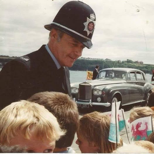
Photo caption:
PC Louis Knight pictured during a Royal Visit, engaging with local children — a familiar sight in Neyland for many years (Pic: Supplied).


Education4 hours ago
Milford Haven school plans unveiled but funding not yet secured
PLANS for a new £100 million school in Milford Haven have been unveiled, but the project has not yet secured...


News5 hours ago
Council unveils plans for new state-of-the-art secondary school in Milford Haven
PEMBROKESHIRE COUNTY COUNCIL has revealed plans for a new state-of-the-art school in Milford Haven, promising modern, inspiring learning spaces for...


Health7 hours ago
NHS waiting list falls — but cancer delays and diagnostic backlog worsen
Record progress claimed by Welsh Government as critics warn key targets are still being missed THE NHS in Wales has...


Crime1 day ago
Rapist jailed after ‘abhorrent’ attacks on woman and children
Haverfordwest man told police “women won’t have sex without force” A HAVERFORDWEST man who raped a woman and a young...


News1 day ago
Reform secures first Pembrokeshire councillor in Hakin by-election win
Late Reform candidate takes seat as independent surge and Labour withdrawal shape contest REFORM UK candidate Scott Thorley has won...


News2 days ago
Scott Thorley elected as Pembrokeshire’s first Reform councillor
REFORM UK candidate Scott Thorley has won the Hakin by-election after securing 179 votes. The full result is as follows:...


News2 days ago
Police confirm man has died after being recovered from River Cleddau
Major emergency response in town centre after concerns raised for man in water A MAN has died after being recovered...

Community2 days ago
Davies and Kurtz urge groups to seek employability funding
Community organisations in Pembrokeshire encouraged to apply for new grants supporting skills and job access LOCAL Senedd Members Samuel Kurtz...


News2 days ago
Emergency services flood Haverfordwest after reports of person in river
Town centre sealed off as multi-agency response continues A MAJOR emergency response is underway in the centre of Haverfordwest after...


News2 days ago
Detectives receive surge of new information in bid to identify man found at Powys reservoir
Public response follows release of facial image as officers pursue fresh lines of enquiry DETECTIVES investigating the identity of a...
-

 Health6 days ago
Welsh Ambulance Service to host bi-monthly Board meeting
-
 News5 days ago
Rayner and Lammy visit Wales to discuss justice and community safety
-
 News4 days ago
Fishguard linked to allegations in Many Tears Animal Rescue investigation
-
News2 days ago
Emergency services flood Haverfordwest after reports of person in river
-
 Charity7 days ago
Many Tears Animal Rescue visited by inspectors as police attend in support role
-
 Local Government5 days ago
Investigation confirmed after inspectors visit Many Tears Animal Rescue
-

 Community6 days ago
Local charity hosts cancer awareness event in Cardigan
-

 Farming7 days ago
Plea to remove decades old ‘unviable’ planning conditions from property