

News
Stephen Crabb MP to defy whips on Universal Credit uplift
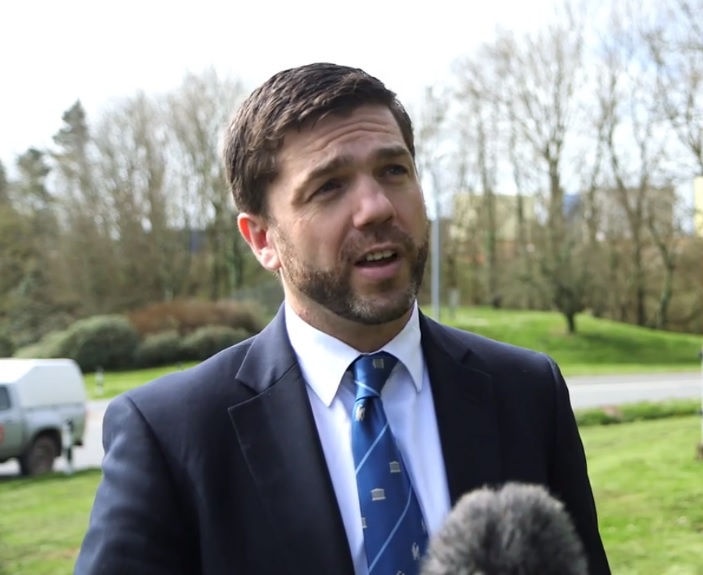
PRESELI MP Stephen Crabb will defy the Conservative whip for the first time today.
The former Work and Pensions Secretary will ignore an instruction to abstain on a non-binding Labour motion to keep the £20 uplift to Universal Credit beyond March 31.
In his Spending Review last November, Chancellor Rishi Sunak refused to commit to keeping the £20 payment. The Chancellor introduced it last year to compensate families of the unemployed or
those on low incomes for the extra costs they incur during the Covid pandemic.
Stephen Crabb has repeatedly made it clear that he wants the £20 top-up to continue to give the poorest and most vulnerable at least some cushion from the effects of the deepening recession.
Although the Westminster Government claims it is optimistic about the economy’s future, the short-to-medium term looks grim.

Many businesses have closed and are unlikely to reopen. Not all of those who lost their jobs will get back into employment. It is likely any jobs on offer once the economy picks up will be low
paid and leave many still dependent on Universal Credit in some form.
Speaking on Times Radio this morning, Mr Crabb said: “No one can say we have a generous benefits system. We don’t. The unemployment component of benefits is at its lowest for a generation.
Withdrawing that additional £20 per week at the end of March will cause hardship. I don’t think it’s the right thing to do.”


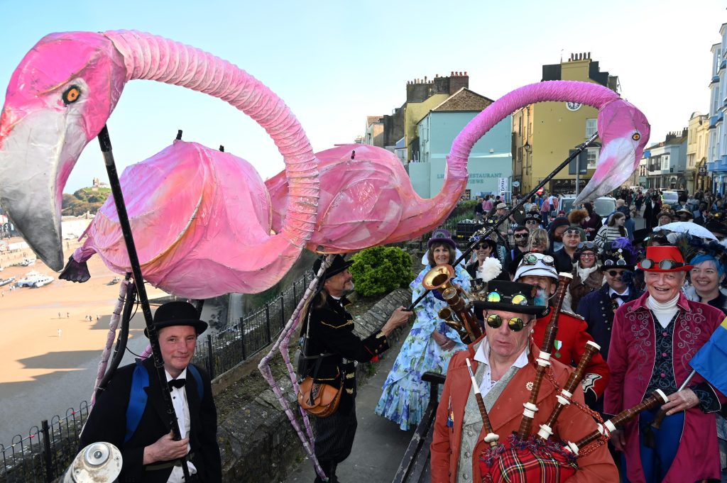
Colourful parade, towering creations and Victorian flair bring town centre to life
TENBY was transformed into a vibrant Victorian fantasy on Saturday (Mar 21) as hundreds of visitors descended on the town for the annual Steampunk Festival.
The highlight of the day came with the much-anticipated Peacock Parade, which saw elaborately dressed participants wind their way through Tenby’s narrow streets, drawing large crowds of spectators.

Residents and visitors lined the route, many stopping to take photos as performers in eye-catching costumes passed by. From brass goggles and top hats to military-inspired uniforms and elegant gowns, the outfits on display reflected the creativity and theatrical spirit of the steampunk scene.
Among the most striking sights were the towering pink flamingo creations, which rose high above the crowds and became an instant talking point. Musicians in period costume added to the atmosphere, playing lively tunes as they marched through the town.
Families were out in force, with children and adults alike enjoying the spectacle. Many visitors had travelled from across Wales and beyond to attend the event, which has grown in popularity in recent years and is now firmly established as a key date in Tenby’s events calendar.
The Herald understands that local businesses also benefited from the influx of visitors, with cafés, pubs and shops seeing a steady flow of customers throughout the day.
In addition to the parade, a range of activities were taking place across the town, including markets, performances and themed entertainment centred around the De Valence Pavilion.
Organisers have worked to create an inclusive and welcoming event, with many people choosing to dress up while others simply come along to enjoy the unique atmosphere.
The festival continues on Sunday, with further events planned as Tenby remains firmly in the grip of steampunk fever for the weekend.


Photos: Colourful characters take part in the Peacock Parade through Tenby on Saturday (Pic: Gareth Davies).
More than 1,200 lives lost each year as charity warns of growing public health crisis
ACCIDENTAL deaths in Wales have risen by 43% over the past decade, with more than 1,200 people now dying each year, prompting calls for urgent action from the next Welsh Government.
New figures released by the Royal Society for the Prevention of Accidents (RoSPA) show that Wales now has a death rate 22% higher than the UK average, with preventable harm placing increasing pressure on the NHS and disproportionately affecting poorer communities.
Falls remain the leading cause of accidental death, accounting for nearly half of all fatalities. People in Wales are around 24% more likely to die from a fall than those elsewhere in the UK.
RoSPA has warned that the situation represents a growing public health crisis, as it launches its Stronger, Safer Wales manifesto ahead of the next Senedd election.
The charity is urging ministers to treat accident prevention as a national priority, arguing that many deaths could be avoided through relatively simple and low-cost interventions.

Accidental harm is also linked to a range of other risks, including rural road collisions, accidental poisonings, machinery incidents, and dog-related injuries.
The wider impact is significant, with preventable accidents costing the NHS billions, reducing workforce participation, and deepening inequality across Wales.
RoSPA is calling for a range of measures, including improved home safety standards, compulsory water safety education in schools, and stronger road safety interventions.
Among its proposals are mandatory eyesight tests for drivers every three years, better road markings to protect motorcyclists, and tighter regulation of unsafe or counterfeit products sold online.

The charity also wants to see national home safety programmes introduced to support vulnerable households, along with clearer responsibilities for local authorities in managing water safety risks.
Becky Hickman, Chief Executive of RoSPA, said the figures should act as a wake-up call for policymakers.
She said: “Wales is facing a clear and escalating crisis of accidental deaths, and the evidence shows the situation is worsening year on year.

“Behind every statistic is a life that could have been saved with practical, proven interventions.
“We are calling on the next Welsh Government to make accident prevention a national priority, because coordinated action will save lives, reduce inequalities and relieve pressure on the NHS.”
She added: “Accidents are not inevitable. With strong leadership and consistent standards across Wales, we can significantly reduce preventable harm.”
RoSPA says tackling the issue will require coordinated action across government, emergency services, local authorities and industry, but insists that the solutions are both achievable and cost-effective.
The charity’s manifesto is intended to shape future policy in Wales, with a focus on reducing avoidable deaths while easing pressure on overstretched public services.
National scheme aims to support hundreds of victims of modern slavery across the UK
MORE than 600 adult survivors of modern slavery are set to receive dedicated support through a new national pilot scheme providing accredited, independent advocates.
The initiative will see specially trained professionals working directly alongside survivors of human trafficking and exploitation, helping them navigate complex legal, social, and recovery processes.
While survivors of crimes such as domestic and sexual abuse already have access to specialist advocacy, no equivalent provision previously existed for victims of modern slavery—despite the often severe and long-term trauma they experience.
Over the next three years, 24 Independent Modern Slavery Advocates (IMSAs) will be deployed across the UK. Each advocate will complete a postgraduate qualification and receive support from a central hub hosted by anti-trafficking charity Hope for Justice.
Tim Nelson, CEO at Hope for Justice, said the pilot aims to tackle inequalities in support: “We want to end the postcode lottery that adult survivors of modern slavery and human trafficking are experiencing in the UK.
“There are many organisations already doing incredible work, but by working together and setting new standards, we can give survivors the best possible chance of rebuilding their lives.”
The scheme is backed by a £1 million National Lottery grant and involves several organisations, including Unseen UK, Medaille Trust, Bawso, SOHTIS, Hope for Justice, and the Snowdrop Project.
Since the pilot began six months ago, advocates have already supported 121 survivors, helping to secure housing, legal recognition, and access to vital services.
Key outcomes so far include:
Ten survivors provided with safe and secure housing
Seventeen Home Office decisions successfully challenged, granting victims access to support
Humanitarian protection secured for a young adult survivor
Advocates have also helped individuals access healthcare, mental health support, education, employment, and secure immigration status.
One survivor described the support as “life changing” after escaping a trafficker. In a letter to her advocate, she said: “You have fought our corner tirelessly when I did not have the strength. You stood beside us every step of the way.

“You helped me rebuild trust, believe in myself, and slowly find my voice again.”
The IMSA role aligns with international guidance on independent advocacy and has been shaped by experts and those with lived experience.
Louise Mensah, Head of Frontline at Unseen, said: “This pilot is a step towards a world without slavery. We are proud to be part of something that will improve outcomes and change futures.”
Ben Ryan, Deputy CEO at Medaille Trust, added: “We know the value of long-term support in recovery. This partnership allows us to embed best practice and develop new approaches.”
Organisations wishing to join the final phase of the pilot have until May 2026 to apply.
Further information is available at www.hopeforjustice.org/imsa/


Entertainment3 hours ago
Tenby steams up in spectacular style as crowds flock to festival
Colourful parade, towering creations and Victorian flair bring town centre to life TENBY was transformed into a vibrant Victorian fantasy...

Crime1 day ago
Publican jailed for six years for supplying cocaine and cannabis
Milford Haven man sentenced at Swansea Crown Court following drug dealing operation A MILFORD HAVEN publican has been jailed for...

Local Government1 day ago
Poverty summit highlights support efforts across Pembrokeshire
A SUMMIT bringing together key organisations from across Pembrokeshire has highlighted both the scale of local poverty and the work...

Education2 days ago
Milford Haven school plans unveiled but funding not yet secured
PLANS for a new £100 million school in Milford Haven have been unveiled, but the project has not yet secured...


News2 days ago
Council unveils plans for new state-of-the-art secondary school in Milford Haven
PEMBROKESHIRE COUNTY COUNCIL has revealed plans for a new state-of-the-art school in Milford Haven, promising modern, inspiring learning spaces for...

Health2 days ago
NHS waiting list falls — but cancer delays and diagnostic backlog worsen
Record progress claimed by Welsh Government as critics warn key targets are still being missed THE NHS in Wales has...


Crime3 days ago
Rapist jailed after ‘abhorrent’ attacks on woman and children
Haverfordwest man told police “women won’t have sex without force” A HAVERFORDWEST man who raped a woman and a young...


News3 days ago
Reform secures first Pembrokeshire councillor in Hakin by-election win
Late Reform candidate takes seat as independent surge and Labour withdrawal shape contest REFORM UK candidate Scott Thorley has won...


News4 days ago
Scott Thorley elected as Pembrokeshire’s first Reform councillor
REFORM UK candidate Scott Thorley has won the Hakin by-election after securing 179 votes. The full result is as follows:...


News4 days ago
Police confirm man has died after being recovered from River Cleddau
Major emergency response in town centre after concerns raised for man in water A MAN has died after being recovered...
-

 News6 days ago
Fishguard linked to allegations in Many Tears Animal Rescue investigation
-

 News4 days ago
Emergency services flood Haverfordwest after reports of person in river
-

 Crime3 days ago
Mother given community order after admitting child cruelty offence
-
Health2 days ago
NHS waiting list falls — but cancer delays and diagnostic backlog worsen
-
 Crime6 days ago
Man cleared of sexual assault allegation after magistrates rule no case to answer
-
 News4 days ago
Senedd votes to ban Greyhound racing in Wales to protect animal welfare
-

 News4 days ago
Senedd vote to ban greyhound racing hailed as ‘landmark moment’ by charities
-

 Sport7 days ago
Wales end Six Nations losing run with bonus-point win over Italy